

Dan Mills – Visceral Cartography: Projects on Colonialism, Conflict, and Culture
Last year the Maine Arts Journal published an essay that focused on the series Chronicle: Colonizing the World Since 1400, and included an overview of my working process. This present submission focuses on an exhibition of my map-related work on view in Maine this fall. Visceral Cartography: Projects on Colonialism, Conflict, and Culture by Dan Mills is at the Bernard and Barbro Osher Gallery at the Osher Map Library and Smith Center for Cartographic Education (OML), University of Southern Maine, Portland, 15 September–23 December 2026. The Osher has long been a resource and source of map information in my practice.

Dan Mills, Hermit, Thoreau, UFOs, and Wabanaki Route Information, acrylic, gouache, and ink on digitally altered map, 14 1/4 x 10 in., 2017 (photo: Luc Demers).
The exhibition is curated by Libby Bischof, the Executive Director of the Osher Map Library, and Paul Fuller, Coordinator of Digital Collections and Digital Initiatives at the Osher Map Library. I have long loved the Osher Map Library collection and the extensive educational programming the staff organizes for campus and the public. The collection is extraordinary, a world-class rare map repository in the state of Maine with over 500,000 objects.
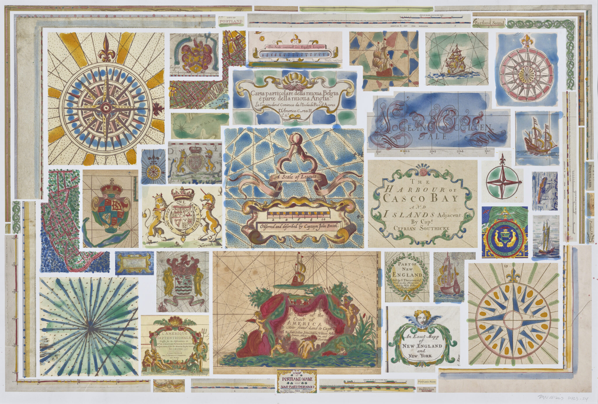
Dan Mills, Stuff from Maps of or That Include Portland, acrylic on digital montage of map details, 16.25 x 24.5 in., 2025 (photo: Luc Demers).
Bischof and I have been discussing the idea of an exhibition of my work at the map library for several years. We eventually landed on the idea of exhibiting works from many different series for the catalogue, selecting maps from the library’s collection that in different ways have a dialogue with the respective series. The exhibition features nearly ninety of my works spanning four decades, including sketchbooks and notebooks that visualize my research process. Libby was particularly keen to curate the work in such a way as to inspire students of all ages to engage in their own map-based research projects, and to see and present the world differently in their own work.

Dan Mills, Poland, Its Shifting Borders, and All Its Legendary, Semi-Legendary, and Historic Rulers 6th Century–1795 (When It Disappeared from the Map for 123 Years), acrylic and ink on printed paper on board, 67 x 71.75 in., 2020 (photo: Luc Demers).
I started incorporating maps into my work in the early 1990s while thinking about the upcoming quincentennial of what was euphemistically referred to as “The First Encounter.” Since then, I have focused on many topical subjects. These topics and the names of series in Visceral Cartography include: colonialism in CHRONICLE (Colonizing Since 1400) and CONTEST; wars and displacement in CURRENT WARS AND CONFLICTS; imperialism in US FUTURE STATES ATLAS; land claims in MAGALLANICA (Everyone Wants a Piece of It); colonialism and indigenous cultures in WHAT’S IN A NAME? and AMAZON REGION; inequities of fulfilling the American dream in LIFE, LIBERTY, AND THE PURSUIT OF HAPPINESS; works about certain places of significance to me in ABOUT PLACE; Global warming and rising waters in UNDERWATER; FICTITIOUS AND ACTUAL LANDS; and a few earlier works.
If you haven’t yet visited the Osher Map Library, please consider doing so this fall to see Visceral Cartography and the library and education center.
From the Press Release: Visceral Cartography: Projects on Colonialism, Conflict, and Culture by Dan Mills is a solo exhibition featuring artwork selected from ten series or Research Projects, plus several early works by the artist. Dan Mills works with archival materials to express historical events and reimagined narratives, collaging elements from maps onto board and other materials, layering many colors of paint and other media on top. He selectively reworks portions of each piece to expose overpainted layers and information. Mills’ extensive research practice informs the visualization of each series, which often explore place-based histories and narratives that are absent from or undermined by mainstream media.
Janelle Delicata

Janelle Delicata, Voyage 1: Charting a Path, mixed media on paper, 15 x 15 in., 2025.
I’ve always enjoyed maps. I remember the AAA TripTiks, charting out vacation routes, Rand McNally’s road atlases, and of course DeLorme’s Maine Atlas and Gazetteer, of which I have several copies, all dog-eared and marked up! Google Maps and GPS navigation systems are wonderfu, but sometimes I need to see the bigger picture. I always have a paper map with me when I travel, and I am often asked for directions even though I too am a tourist traveler.

Janelle Delicata, Voyage 2, mixed media on paper, 15 x 15 in., 2025.
Charts, maps, plotting graphs, and checklists are things I come across teaching at a maritime college. I found some plotting graph pages which have a technical name, but to my artist’s eye were interesting graphic images, and thought I would try to incorporate them into my work. As I worked, drawing, stamping, painting, and making my marks on the pages, I began to think of voyages, charting courses, tracking, and mapping out routes. This started a series called Voyages which is still in progress.

Janelle Delicata, Voyage 3: Charting My Life, mixed media on paper, 15 x 15 in., 2026.
I am also a list-maker. I realized that lists are a kind of map—my shopping list basically charts my path through the grocery store, with the items listed in the general order in which they are found. I make “to do” lists—every morning I make a list of things I need or want to accomplish during the day or other time period. I may skip around on this list but I cross off each task as it is completed. I think if I didn’t make these lists I probably wouldn’t get much done, so lists become a kind of guide or map for daily life.

Janelle Delicata, Voyage 4: Possible Path, mixed media on paper, 15 x 15 in., 2026.
I think we make maps without realizing we do so. We might not call them maps or even recognize them as such, but what gets planted where in the garden, where you stashed the box of holiday lights, which boxes have the winter boots, these are maps. We are constantly trying to organize and order our lives and environments and we are making maps to help us along the way.
Amy Bellezza – Home and Place

Amy Bellezza, Winter, photo collage, 17 x 22 in.
I took “belonging” to mean something deeper: being part of the land, the state, my town and city, my neighborhood and community, and ultimately, my home.

Amy Bellezza, Spring, photo collage, 17 x 22 in.
Using a seasonal image and map as the background, I placed a small framed photograph of my rustic kitchen within each composition. The background is printed on unframed canvas to represent the raw, natural character of Maine. In contrast, the smaller photographs are printed on glossy paper and framed, evoking the feeling of family snapshots and personal memories.

Amy Bellezza, Summer, photo collage, 17 x 22 in.
All of the intimate photographs were taken in my kitchen, a place I consider the heart of the home. By bringing these personal images into the larger landscape, I am connecting the natural world outside with the warmth and memories of home inside.

Amy Bellezza, Fall, photo collage, 17 x 22 in.
Each of the four backgrounds contains trees, symbolizing that I am “rooted” here. I created all four seasons to represent my connection to Maine throughout the entire year and to express that I am a year-round Mainer. Together, the four pieces speak to my sense of belonging—not simply to a place, but to a landscape, a community, and a home that have become part of who I am.

Full view of image at top: Dan Mills, Current Wars and Conflicts by Country, with Ancient Symbols, ink and graphite on printed paper, 22.5 x 30 in., 2015 (photo: Luc Demers).